Nicomekl Riverfront Park
Read our territory acknowledgement

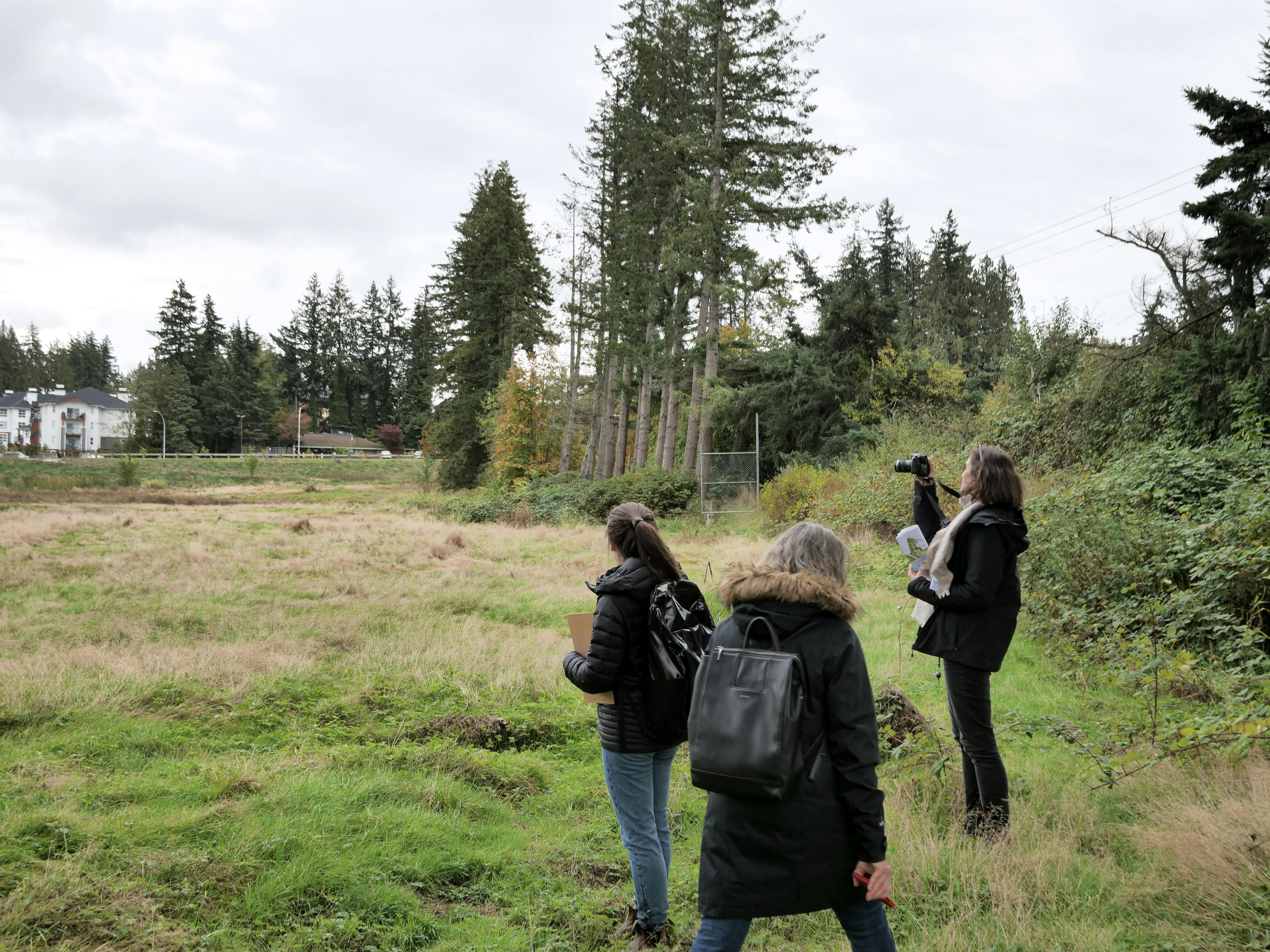
Thank you for your input!
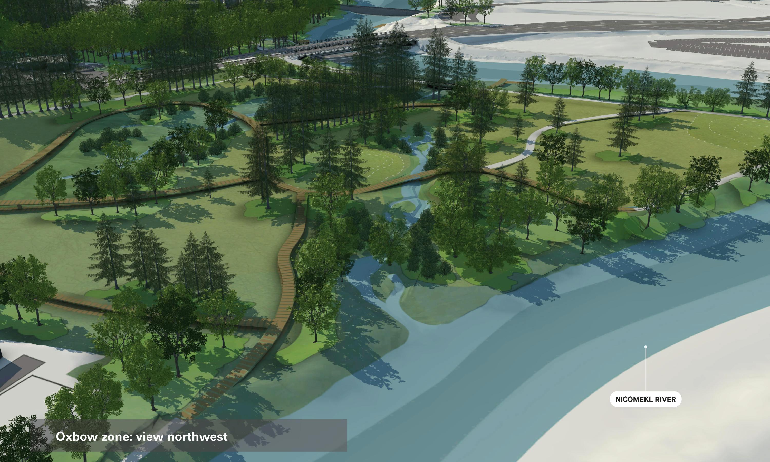
The concept design for phase 1 of the park is now completed. On Monday November 20, 2023, Council approved the final concept plan for the Nicomekl Riverfront Park Phase 1 Hadden Mill and Oxbow Zones.
The detail design is underway to develop construction blueprints.
Read the engagement summary.
View the final concept plan.
We are excited to show you the design of phase 1 of the Nicomekl Riverfront Park. Phase 1 has two large park spaces, the Hadden Mill and Oxbow zones, located on either side of King George Boulevard.

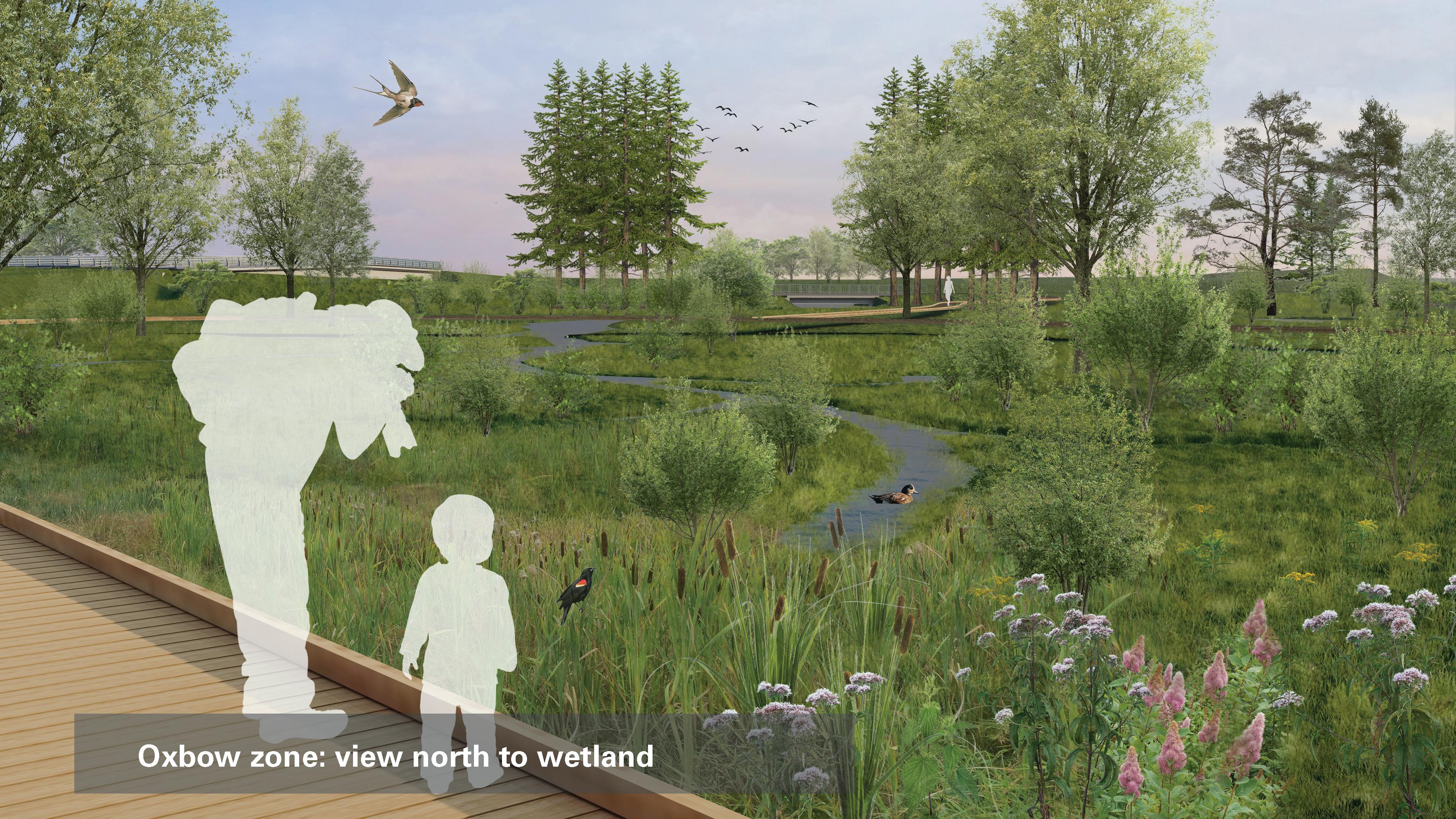
View the discussion guide to learn more. The guide shows the draft concept plan and diagrams about park spaces, trails, entrances, flooding, habitat types, and nature-based infrastructure elements.
A park for people, wildlife and water
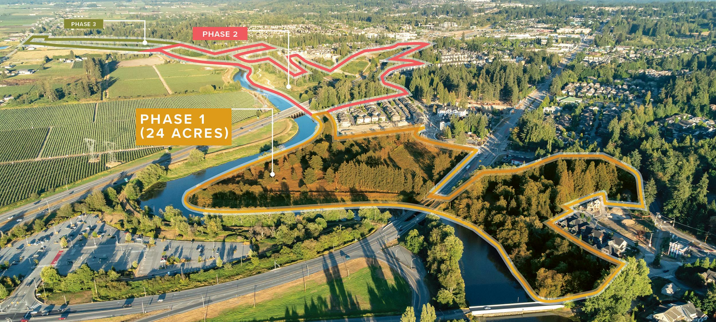
Surrey has over 800 parks and one park is uniquely adapting to climate change by making room for the river: the future Nicomekl Riverfront Park. Located on the south side of the Nicomekl River in South Surrey, this 3km linear park will extend from Elgin Rd to 40th Ave. 80 acres in size, the future nature park will be 14 times larger than Crescent Beach Park.
This is a big park with a big impact and it will take time to do it right.
Designing and constructing an 80-acre nature park along one of Surrey’s major river systems is complex and innovative project with numerous long-term benefits.
The park will be built in 3 phases. We are currently designing phase 1, the Hadden Mill and Oxbow zones.

Based on Surrey's Coastal Flood Adaptation Strategy, the park will turn planning into action to address sea level rise and coastal flooding.
This project is funded in part by the Government of Canada through the Disaster Mitigation and Adaptation Fund.
Goals
With your feedback (thank you!) we completed the park management plan and it was adopted by Council in spring 2020. The plan is a guiding document for the design and construction of the park. See the plan and supporting documents in the planning documents (right).
While designing phase 1, we updated the goals from the park management plan. These goals are:
- Centering Semiahmoo, Kwantlen, and Katzie values, ways of doing and knowing
- Reconnecting with land and water
- Celebrating the river
- Learning and cultural exchange
- Sustaining all forms of life
- Adapting to a changing climate
Territory acknowledgement
We acknowledge that Surrey and the Nicomekl Riverfront Park are on the traditional unceded territories of the Coast Salish Peoples, including the q̓ic̓əy̓ (Katzie), q̓wɑ:n̓ƛ̓ən̓ (Kwantlen), and səmyámə (Semiahmoo) land-based Nations. The parkland is also the traditional territory of the Snokomish peoples, a Nation decimated by smallpox. We are uninvited guests on this land.
– The Nicomekl Riverfront Park Project Team
-
Detailed design for Phase 1 is underway!

The detailed design for Phase 1 of the park is currently in progress. As part of the process, the project will submit multiple provincial permit applications, including approval to decommission the existing dike and build a new dike in the Oxbow zone. An environmental impact assessment has been completed, confirming that the project will enhance and diversify the park’s ecological features.
For detailed information on the work to date, check out the discussion guide.
-
Help finalize the design for the new Nicomekl Riverfront Park

City seeks public feedback on phase one design of Surrey’s new 3km riverfront park.
June 15, 2023
Surrey, B.C. – The City of Surrey is seeking community input on the proposed design for a new 3km linear park planned along the Nicomekl River. Residents, user groups, stewards, First Nations and other interested parties are invited to provide feedback on the project by attending an open house happening on Tuesday, June 20 at Elgin Hall from 5p.m. to 7p.m. or by taking the online survey, which closes on July 14.
“We are really excited to share the design of the new Nicomekl Riverfront Park with the community,” said Mayor Brenda Locke. “By using low impact construction techniques, this new park is designed with an eco-friendly approach in order to preserve sensitive plants, trees and wildlife. Once completed, the Nicomekl Riverfront Park will have new trails, kayak and canoe docks, a playground, and viewpoints for all to enjoy.”
The project is being developed in three phases. The City of Surrey is currently gathering feedback on the design for phase one, the largest area (24 acres) of the project, known as the Hadden Mill and Oxbow zones, located on either side of King George Boulevard. Feedback gathered will help finalize the phase one concept plan and initiate the construction phase of the project. This is the final round of engagement for phase one of the project.
Indigenous Coast Salish culture, history, stories, and art will be present in multiple locations throughout the park. Artists from Semiahmoo and Kwantlen First Nations are developing cultural pieces and advising on the park design. This cultural work will create opportunities for reconnection with this land, and for all peoples to learn about Coast Salish history and culture.
The project is one of Surrey’s 13 projects to be partially funded through the Government of Canada’s Disaster Mitigation and Adaptation Fund (DMAF). The project was also approved in the City’s 2021 Five-Year (2021-2025) Capital Financial Plan.
The new Nicomekl Riverfront Park will be part of the network of over 800 parks managed by the City of Surrey. 600 parks prioritize protecting natural areas, open space, and biodiversity as part of the larger green infrastructure network and over 200 parks feature active amenities such as sports fields, sport courts, playgrounds, community gardens, picnic areas.
Take the survey and learn more.
-
See the Phase 1 design and get ready to tell us what you think!

Read the discussion guide to see the design of the Hadden Mill & Oxbow zones (Phase 1). Get ready to take the online survey (June 14-July 14) and attend the public open house (June 20). Your input matters – it will help us finalize the park concept plan in late summer. Construction drawings, permits, and construction will follow.
The discussion guide shows the draft concept plan and diagrams about park spaces, trails, entrances, flooding, habitat types, and nature-based infrastructure elements.

-
Concept Design Underway for First Phase of Surrey’s New 3KM Riverfront Park

September 29, 2022, Surrey, BC
The City of Surrey has released an update on the development of the concept design of phase one of the new Nicomekl Riverfront Park in preparation for a public engagement campaign planned in early 2023. The report provides residents with information on what has been completed to date, what is happening next, the site’s history and significance and the principles and rationale being used to plan and design the park. A more detailed update, including drawings and renderings, will be released closer to the date of the public engagement in 2023.
“We are pleased withContinue reading
-
Nicomekl Dog Off-Leash Area is Open

The Nicomekl Dog Off-Leash Area (3435 150 St) is complete.
With around 1 acre of fenced open space, this new Dog Off-Leash area will be accessible from the multi-use pathway which connects to Barbara Creek Park and the Rosemary Heights West and King George Corridor neighbourhoods. Note that it will offer the same area for dogs of different sizes.
Explore the other dog off-leash parks across Surrey.
There is no parking at the dog park. Walking to the dog park is encouraged.
-
City Awards Design Contract for Phase One of Nicomekl Riverfront Park
July 29, 2021, Surrey, BC
The City of Surrey awards the contract for the design services for phase one of the Nicomekl Riverfront Park to a multidisciplinary consulting team led by space2place design inc. Phase one includes the development of the Hadden Mill and Oxbow zones, which are on the south side of the Nicomekl River adjacent to King George Boulevard.
The Nicomekl Riverfront Park is a park for the future. It will be developed over multiple years as a multi-phased project. When complete, it will be a 3km long, 80-acre riverfront park incorporating ecology, heritage, public art, recreation, infrastructureContinue reading
-
Surrey’s Coastal Flood Adaptation Strategy Honoured with Two National Awards
October 1, 2020, Surrey, BC
Surrey's Coastal Flood Adaptation Strategy received national recognition from the Canadian Association of Municipal Administrators (CAMA) and the Canadian Institute of Planners (CIP) for excellence in environmental planning. The City is taking action on this award-winning strategy with 13 projects funded in part by the Government of Canada, including the Nicomekl Riverfront Park.
“Our CFAS plan is making historic investments to protect and improve the environment and natural infrastructure our residents depend on,” said Mayor Doug McCallum. “These awards demonstrate our unwavering commitment to building Surrey’s resilience to coastal flooding and sea level rise, furtherContinue reading
-
Nicomekl Riverfront Park Management Plan wins a Gold Award from the Planning Institute of British Columbia
June 25, 2020, Surrey, BC
The Planning Institute of British Columbia (PIBC) has awarded Surrey’s Nicomekl Riverfront Park Management Plan with the 2020 Gold Award for Excellence in Planning Practice for a City & Urban Area. The PIBC awards are presented annually in recognition of the professional planning work and accomplishments of members across British Columbia and Yukon.
“The City of Surrey is committed to creating a healthy, green, and inclusive community for our residents and we are honoured to receive this award from the Planning institute of British Columbia,” said Mayor Doug McCallum. “Improving the quality ofContinue reading
-
Canada helps protect Surrey from disastrous impacts of flooding
May 24, 2019, Surrey, BC
Now more than ever, communities need help adapting to the frequent and intensifying weather events caused by climate change. Reducing the impact of natural disasters such as flooding is critical to keeping Canadian families safe, protecting local businesses and supporting a strong economy and the middle class.
Today, the Honourable Carla Qualtrough, Minister of Public Services and Procurement and Accessibility on behalf of the Honourable François-Philippe Champagne, the Minister of Infrastructure and Communities, announced funding to support a number of initiatives to safeguard the cities of Surrey and Delta and the Semiahmoo First Nation fromContinue reading
-
Rising Tides are Predictable, and the City of Surrey isn’t Waiting
February 22, 2018, Surrey, BC
With global sea levels rising, coastal communities like Surrey face a significant challenge. While the coastal flooding threat is not imminent, it is predicted that the sea level will rise by one metre in 2100, and two metres by 2200, which is why the time to plan is now. Surrey has taken a leading position to proactively advance efforts aimed at increasing community resiliency, safety and health.
The City of Surrey’s Coastal Flood Adaptation Strategy (CFAS) is a participatory, community-driven planning approach to exploring the impacts of climate change on Surrey’s coastline, and the long-termContinue reading

Who's listening
-
Park Design Co-Lead, Landscape Architect
MWEmail nicomeklpark@surrey.ca -
Park Design Co-Lead, Landscape Architect

Email nicomeklpark@surrey.ca -
Parks Planning Technician
BWEmail nicomeklpark@surrey.ca
Subscribe to project updates
Keep up to date on the future Nicomekl Riverfront Park.

Videos
-
 July 2021: Surrey has over 800 parks and one park is uniquely adapting to climate change by making room for the river, the future Nicomekl Riverfront Park. Located on the south side of the Nicomekl River in South Surrey, this 3-km linear park will extend from Elgin Rd to 40 Ave.
-
 Aug 2018: What’s important to you in shaping Surrey’s longest riverfront park? Come on a journey with us to plan the new Nicomekl Riverfront Park.
-
Feb 2019: Metro Vancouver – The City of Surrey celebrates World Wetlands Day with a public tour of the future Nicomekl Riverfront Park in South Surrey.
-
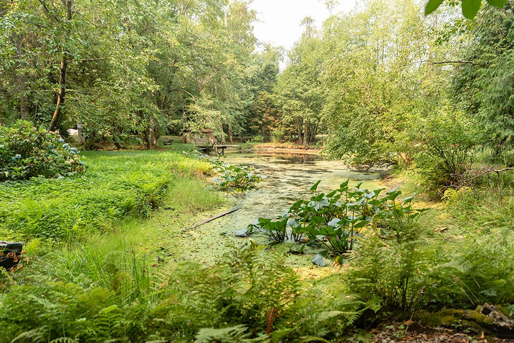
Jul 2019: Nicomekl Nature Kids group explores the old salmon ponds at the future Nicomekl Riverfront Park.
-
Jul 2019: Local resident Nicole paddles on the Nicomekl River and shares her vision for the future Nicomekl Riverfront Park.